


sentier du blaireau jusqu'en Ecosse

Regisconraud
User
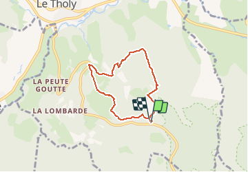

Length
5.3 km

Max alt
845 m

Uphill gradient
184 m
Km-Effort
7.8 km

Min alt
670 m

Downhill gradient
185 m
Boucle
Yes
Creation date :
2020-05-17 12:51:16.748
Updated on :
2020-05-17 14:37:52.545
1h46
Difficulty : Very easy

FREE GPS app for hiking
 SityTrail
IGN / Geographical institutes
SityTrail Plus
The world is yours!
About
Trail Walking of 5.3 km to be discovered at Grand Est, Vosges, Le Tholy. This trail is proposed by Regisconraud.
Photos


Positioning
Country:
France
Region :
Grand Est
Department/Province :
Vosges
Municipality :
Le Tholy
Location:
Unknown
Start:(Dec)
Start:(UTM)
333704 ; 5325771 (32U) N.
Comments